PAGE MENU
NE Wales
North Wales
NE Wales


Click on the thumbnail image to get an enlargement which have been annotated to show the most prominant or important features.
Not only are there excellent views of Snowdon itself but also Gwydyr Forest and the Conwy valley. To the east the Hiraethog Moors and Clocaenog forest before crossing the Vale of Clwyd and the steep front of the Clwydian Mountains betwen Mold and Ruthin which offers some of the most accessible and extensive all season riding.
The southern area of North Wales is probably notable for mountain bikers because of Coed y Brenin, but apart from that and a number of othr forests there is a distinct lack of a continuous off tarmac network, especially around Bala. The eastern Berwyn Mountains are high and have a number of historic passes which were bypassed when the man with tarmac arrived.
Other areas that offer extensive opportunity is North Powys, otherwise known as the the old county of Merionethshire stretching from the englich border near Welshpool onto Machynlleth and the Dyfi estuary.
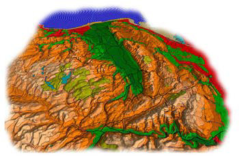
The below image of the Vale of Clwyd is has been derived from mainly a digital terrain model with the colours representing height apart from the forestry, lakes and roads that have been added as an overlay.